
Typhoon Warning Upgrade! May Directly Strike Zhejiang-Jiangsu Coast on 30th; Yangshan Port Empty Container Operations "Stopped and Restarted Today" 台风预警升级!30 日或直击浙苏沿海,洋山港空箱作业 “停了又开”
Typhoon Warning Upgrade! May Directly Strike Zhejiang-Jiangsu Coast on 30th; Yangshan Port Empty Container Operations "Stopped and Restarted Today"
台风预警升级!30 日或直击浙苏沿海,洋山港空箱作业 “停了又开”
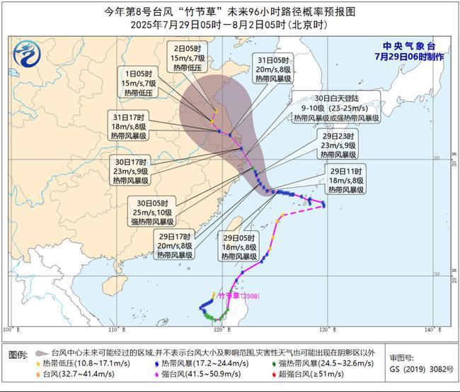
CCTV News: The Central Meteorological Observatory (CMA) continued to issue a blue typhoon warning at 06:00 on July 29. As of 05:00 today (29th), the center of this year's 8th typhoon, "Zhujiecao" (tropical storm), was located in the southern part of the East China Sea, approximately 425 kilometers southeast of Zhoushan City, Zhejiang Province, at 27.3°N latitude and 125.3°E longitude. The maximum sustained winds near the center were Force 8 (18 meters per second), with a minimum central pressure of 992 hPa. The radius of the gale-force wind circle (Force 7) is 200-300 kilometers.
央视网消息:中央气象台7月29日06时继续发布台风蓝色预警,今年第8号台风“竹节草”(热带风暴级)的中心今天(29日)早晨5点钟位于浙江省舟山市东南方向约425公里的东海南部海面,就是北纬27.3度、东经125.3度,中心附近最大风力有8级(18米/秒),中心最低气压为992百帕,七级风圈半径200-300公里。
Source: CCTV News
图源央视新闻
It is expected that "Zhujiacao" will move towards the northwest at a speed of 15-20 kilometers per hour, and its intensity will gradually increase. It is expected to make landfall along the coastal areas from Sanmen, Zhejiang to Qidong, Jiangsu during the day on July 30 (23-25 meters/second, 9-10 levels, tropical storm level or strong tropical storm level). After landing, its intensity will gradually weaken. It is also possible that it will move northward near the northern coast of Zhejiang.
Wind Forecast: From 08:00 on July 29 to 08:00 on July 30, the southern Yellow Sea, most parts of the East China Sea, Hangzhou Bay, the mouth of the Yangtze River, the coastal areas of Shanghai, Zhejiang, and southern Jiangsu will experience winds of 7-8 levels, with gusts of 9-10 levels. In some areas or sea areas through which the typhoon center passes, the wind force can reach 9-10 levels, with gusts of 11-12 levels.
Precipitation Forecast: From 08:00 on July 29 to 08:00 on July 30, some areas in central and northern Jiangsu, Shanghai, eastern Zhejiang, southeastern Fujian, Guangdong, eastern Guangxi, and Taiwan Island will experience heavy to severe rain. Among them, some areas in Shanghai, central and northern Zhejiang, and southern Taiwan Island will experience severe to extremely severe rain (250-300 millimeters). The above-mentioned areas will also experience short-term heavy precipitation (with the maximum hourly rainfall of 20-60 millimeters).
预计,“竹节草”将以每小时15-20公里的速度向西偏北方向移动,强度逐渐增强;将于30日白天在浙江三门到江苏启东一带沿海登陆(23-25米/秒,9-10级,热带风暴级或强热带风暴级),登陆后强度缓慢减弱。也有可能在浙江北部近海北上。
大风预报:7月29日08时至30日08时,黄海南部、东海大部、杭州湾、长江口区、上海沿海、浙江沿海、江苏南部沿海将有7-8级、阵风9-10级的大风;台风中心经过的部分海域或地区风力可达9-10级、阵风11-12级。
降水预报:7月29日08时至30日08时,江苏中北部、上海、浙江东部、福建东南部、广东、广西东部、台湾岛等地部分地区有大到暴雨,其中,上海、浙江中北部、台湾岛南部等地部分地区有大暴雨,局地特大暴雨(250-300毫米)。上述部分地区伴有短时强降水(最大小时降雨量20-60毫米)。
Precautionary Measures:
- Governments and relevant departments should do a good job in typhoon prevention and emergency rescue work according to their responsibilities.
- Water operations in relevant waters and passing ships should return to the harbor to avoid the wind, reinforce port facilities, and prevent ships from drifting, running aground, and colliding.
- Stop large outdoor gatherings and high-altitude and other outdoor hazardous operations.
During the typhoon, the sea waves are huge, which seriously affects the stability and operability of ships and can easily cause ship capsizing and other maritime accidents. At the same time, short-term strong winds also increase the risk of ships drifting while at anchor. After the typhoon passes and heavy rain hits, it will cause damage to the waterway and facilities. "Strong winds and huge waves may cause damage to waterways, buoys, port facilities, etc. If not repaired in time, they can easily block normal port traffic and cause secondary disasters."
Port enterprises should scientifically arrange port operations, ensure the safety of personnel, equipment, and goods, especially strengthening the typhoon prevention work for dangerous goods that burn or explode when encountering water and large port machinery. At the same time, port passenger stations should also take measures to prevent rain and slipping during the rainy season to ensure port production safety. On the other hand, it is also necessary to strengthen the inspection, duty, and maintenance of waterways and waterway facilities, carry out emergency repair work in time, and strengthen the operation safety management of shipping hub dams and navigation structures to ensure flood control safety.
防御指南:
1.政府及相关部门按照职责做好防台风抢险应急工作。
2.相关水域水上作业和过往船舶应当回港避风,加固港口设施,防止船舶走锚、搁浅和碰撞。
3.停止室外大型集会和高空等户外危险作业。
台风期间,海上风浪大,严重影响船舶的稳定性和操作性,极易造成船舶倾覆等水上交通事故,同时,短时大风也增加了锚泊船舶走锚的风险台风过境和暴雨侵袭,将造成航道和设施受损。“大风与巨浪可能对航道、航标、港口设施等造成破坏,如未能及时修复,极易阻塞港口正常交通,造成次生灾害。”
港口企业应科学安排港口作业,做好人员避险、设备避风、货物避水,特别是加强遇水燃烧爆炸危险品和大型港口机械的防台风工作,同时,港口客运站要做好雨季防淋、防滑等措施,确保港口生产安全;另一方面,也要加强对航道及航道设施的巡查、值守和维护,及时开展抢通保通工作,加强航运枢纽大坝和通航建筑物运行安全管理,确保防汛度汛安全。
Yangshan Port Suspends Empty Container Operations for Typhoon Prevention, Resumes Today!
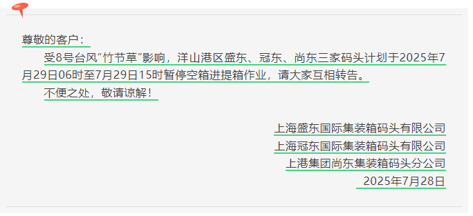
Affected by this year's No. 8 Typhoon "Zhujiecao," the Yangshan Port Area in Shanghai is about to face strong winds and heavy rain. In order to ensure the safety of port operations and the life and property of personnel, after an emergency consultation by the port authorities, it was decided that:
The three container terminals in the Yangshan Port Area, namely Shengdong, Guandong, and Shangdong, will suspend all empty container pick-up and delivery operations from 06:00 to 15:00 on July 29, 2025.
洋山港暂停空箱作业防台风,今日又恢复!
受今年第8号台风“竹节草”正面影响,上海洋山港区即将迎来强风暴雨天气。为确保港口作业安全和人员生命财产安全,经港务部门紧急会商决定:
洋山港区盛东、冠东、尚东三家集装箱码头将于2025年7月29日06:00至15:00期间暂停所有空箱进提箱作业。
图源网络
Latest News!!!
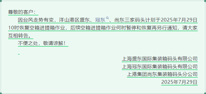
Due to changes in the typhoon's path, the three terminals of Shengdong, Guandong, and Shangdong in the Yangshan Port Area plan to resume empty container pick-up and delivery operations at 10:00 on July 29, 2025. The time for the suspension and resumption of subsequent empty container pick-up and delivery operations will be notified separately. Please inform each other.
Typhoons are unpredictable, so please pay close attention to port dynamics!
Adjust plans in advance: Please adjust the empty container transportation plans in a timely manner to avoid empty vehicle trips.
Pay attention to the resumption time: Please closely monitor weather forecasts and port announcements to understand the time when operations resume.
Safety first: Do not force your way to the port during the typhoon to ensure the safety of personnel and vehicles.
Share information: Please forward this notice to relevant partners and drivers in a timely manner.
At the same time, with the heavy rainfall brought by the typhoon, the water level during the flood season rises sharply, and the safety of ship anchorage is a concern.
最新消息!!!
因台风走势有变,洋山港区盛东、冠东、尚东三家码头计划于2025年7月29日10时恢复空箱进提箱作业,后续空箱进提箱作业何时暂停和恢复再另行通知,请大家互相转告。
图源网络
台风路线多变,请大家及时关注港口动态!
提前调整计划:请相关货代、船代公司及时调整空箱调运计划,避免车辆空跑
关注恢复时间:请密切关注气象预报和港口公告,及时了解作业恢复时间
安全第一:台风期间请勿强行前往港区,确保人员和车辆安全
信息互通:请将此通知及时转发给相关合作伙伴和司机师傅
同时,随着台风天气带来大量降水,汛期水位暴涨,船舶进出锚地、锚泊安全面临挑战。
Flood Season Water Level Rises Sharply, Anchorage Safety Needs Attention
"Mid-July to Mid-August" refers to the flood control critical period from July 16 to August 15 every year. During this time, rainfall in China is distributed in a pattern of "more in the north and south, less in the middle," with more extreme weather and climate events. The Yangtze River main line continues to maintain a high water level and large flow, with increased local water flow speed and chaotic flow patterns. The probability of accidents such as ships drifting while at anchor, breaking chains, and colliding with or touching other ships increases significantly, posing a severe challenge to ship anchorage safety.
On July 6, affected by sudden strong convective weather, the Fengjie Odor Salt Beach anchorage was hit by a level-seven strong wind, and several waiting ships had anchor drifting emergencies.
On July 10, several ships in the Wushan Jiangdong Temple waters drifted due to sudden water level changes and strong winds. A total of 10 ships were out of control and drifted. Five ships regained power and freed themselves, but the remaining five ships completely lost power and were swept towards the main channel with the rapid current, seriously threatening navigation safety.
汛期水位暴涨,锚泊安全需注意
“七下八上” 是指每年7月16日至8月15 日的防汛关键期,此时我国降雨呈“南北多、中间少”分布,极端天气气候事件偏多;而长江干线持续保持高水位、大流量,局部水流流速加大、流态紊乱,船舶锚泊期间发生走锚、断链从而导致触碰、碰撞等事故险情的几率明显上升,船舶锚泊安全面临严峻挑战。
7月6日,受突发强对流天气影响,奉节臭盐碛停泊区遭遇七级大风袭击,多艘待闸船舶出现走锚险情,情况紧急。
7月10日,巫山江东寺水域多艘船舶因水位突变及大风影响,发生走锚漂移,共计10艘船舶失控漂流,其中5艘恢复动力自行脱困,但还有5艘完全失去动力,随着急流冲向主航道,严重威胁通航安全。
How to Prevent Ship Anchor Drifting?
Before anchoring, ships should choose suitable anchorage areas according to the actual situation of the ship and collect hydrological and meteorological information in advance.
During anchoring, pay attention to the flood season water flow at all times, display anchor lights and shapes as required, and check the anchor chain tension in a timely manner.
Duty personnel should perform their anchor watch duties, maintain regular lookout, and pay attention to the movements of surrounding ships to prevent other ships from drifting and endangering the safety of this ship.
Ships entering and leaving the anchorage should choose the right time and position, strengthen lookout, announce their movements in advance, pay attention to the coordination of the engine and rudder, and actively give way to normally navigating ships.
Ships entering and leaving the anchorage should maintain a safe distance from other anchored ships, fully consider the impact of flood season water flow on ship handling, and choose an appropriate speed.
Ships entering and leaving the anchorage should strictly follow relevant regulations and requirements and implement safety measures such as tugboat assistance.
如何防止船舶走锚?
1、锚泊船在锚泊前要根据本船实际情况选择合适的锚地,提前收集好水文气象信息。
2、锚泊过程中时刻关注汛期水流情况,按规定显示锚泊号灯号型,及时检查锚链受力情况。
3、值班人员要履行好锚泊值班职责,保持正规瞭望,随时关注周围船舶动态,以防他船走锚危及本船安全。
4、船舶进出锚地要选择合适的时机和位置,加强瞭望,提前发布动态,注意车舵配合,主动避让正常航行船舶。
5、船舶进出锚地要与其他锚泊船保持安全距离,充分考虑汛期水流对船舶操纵的影响,选择合适的航速。
6、船舶进出锚地要严格按照相关规定要求,落实拖轮维护等安全措施。
In the face of this year's No. 8 Typhoon "Zhujiacao," the typhoon prevention work of ports and ships is particularly important. Port enterprises should closely monitor the typhoon's development, promptly adjust operational plans, and avoid vessels undertaking risky operations during the typhoon. Vessels need to select appropriate anchorages or shelters based on the typhoon's intensity and path, and head out to sea for shelter if necessary.
面对今年第8号台风“竹节草”的来袭,港口和船舶的防台风工作显得尤为重要。港口企业应密切关注台风动态,及时调整作业计划,避免船舶在台风期间冒险作业。船舶则需根据台风的强度和路径,选择合适的锚地或避风港,必要时提前出海避风。
 RELATED NEWS
 Hotline
 Email
Email

 沪公网安备 31011502016705号
Disclaimer:
This communication has been prepared for general information only. To the maximum extent permitted by law, E-PORTS and its affiliated companies, its and their employees, directors, agents, contractors (of any tier) and partners shall not be liable for any loss, claim, charge, damage, liability or damages howsoever arising in connection with the information even if advised of the possibility of damages. The use of the information shall be at your sole risk. Information contained herein comes with no representation or warranty (express or implied) and specifically is not represented or warranted to be correct, complete, accurate or up to date. The information is provided on an “as is” and “as available” basis and is not intended to be relied upon in any way. You shall be solely responsible for the selection, use, efficiency and suitability of the information.


 Chat with us