
Breaking News!Kiel Canal Accident——French Cable-Laying Ship Collides with Lock 突发!基尔运河事故:法国布缆船撞闸
Ⅰ、A Collision That Could Have Been Avoided
一、一场本可避免的“碰撞”
On March 8, a French cable laying ship, en route to the Baltic Sea to repair undersea cables, collided with the gate of the Holtenau lock in the Kiel Canal. The ship's stern lost control and struck the rear of the lock gate.
The vessel frequently travels through the Kiel Canal, and this was its fifth voyage since November of last year. This journey aimed to repair cable networks damaged by natural erosion or external forces. Such missions are crucial for ensuring the stability of Europe's undersea communication and energy transmission, requiring strict adherence to timelines.
Witnesses at the scene reported that the ship approached the lock at an unusually high speed and failed to adjust its course in time, resulting in the destruction of several wooden fenders, with some debris sinking underwater. The Kiel Canal and Waterways Authority (WSA) immediately cordoned off the area and launched an investigation.
On March 10, officials from the Kiel Canal and Waterways Authority (WSA) inspected the damage. According to their report, several wooden fenders were destroyed, with fragments lodged underwater. A WSA representative stated that the damage was minor and could be repaired quickly. The ship, after being questioned by the water police, resumed its voyage around 9 p.m. local time on the same day.
3月8日,法国布缆船在前往波罗的海执行海底电缆修复任务期间,于基尔运河霍尔特瑙船闸南闸室发生撞击事故,船尾失控撞上闸门尾部。
该船经常往返基尔运河,此次是自去年11月以来的第五次航行,此次航行旨在修复因自然侵蚀或外力受损的电缆网络。此类任务对保障欧洲海底通信和能源传输至关重要,需严格把控时效性。
事故发生时,目击者称船舶以异常速度接近闸室且未及时调整航向,导致多个木质浮动护舷损毁,部分碎片沉入水下。基尔运河航道与航运管理局(WSA)随即封锁现场并展开调查。
基尔运河航道与航运管理局(WSA)官员于3月10日勘察了受损情况。据报告,多个木质浮动护舷被撞毁,碎片卡在水下。WSA代表表示,损坏程度不大且可快速修复。该船在接受水警问询后,于当日当地时间晚上9点左右恢复航行。
Ⅱ、Cause of the Accident: Human Oversight as the "Fatal Blow"
二、事故原因:人为疏漏成“致命一击”
1.Technical Failure or Operational Error?
Preliminary investigations revealed that the direct cause of the accident was a coordination failure in the bridge control system. The steering gear and propeller control stations on the bridge's side wing were not activated, resulting in the ship's loss of steering and power regulation capabilities. However, this "technical failure" was actually a human oversight—the captain failed to confirm that all control systems were activated before entering the lock, as required by procedure.
2. The Captain's Dual Pressures
Further analysis suggests that the captain may have streamlined operational procedures due to the urgency of the mission. The Kiel Canal has a high density of traffic, and lock scheduling must strictly follow a timetable. Delays can cause a chain reaction. Additionally, the "confidence from experience" gained from frequent travel along the same route may have diminished the crew's risk awareness.
- 技术故障还是操作失误?
初步调查显示,事故直接原因是驾驶台控制系统的协调失误。驾驶台侧翼的舵机与螺旋桨操控台未被激活,导致船舶失去转向与动力调节能力。然而,这一“技术故障”实为人为疏漏——船长在进入船闸前未按规程确认所有操控系统处于启动状态。
- 船长的双重压力
进一步分析指出,船长可能因任务紧迫性而简化操作流程。基尔运河通航密度高,船闸调度需严格遵循时间表,延误可能导致连锁反应。此外,频繁往返同一航道带来的“经验自信”,也可能削弱了船员的风险警觉。
Ⅲ Introduction to the Kiel Canal
三、基尔运河情况介绍
- Geographical Location
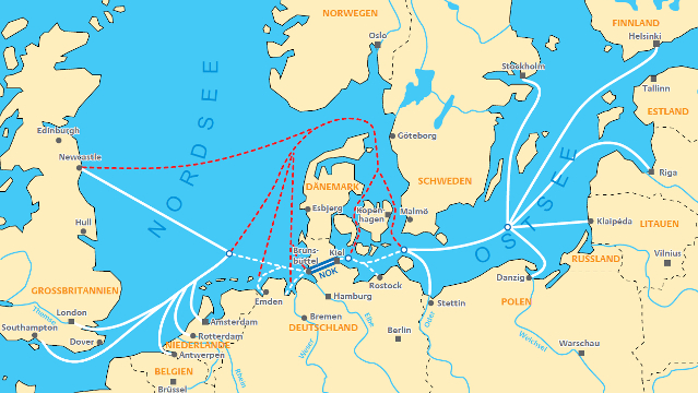
The Kiel Canal, also known as the Nord-Ostsee-Kanal, is a vital waterway connecting the North Sea and the Baltic Sea and is indispensable for the Port of Hamburg. It is located in northern Germany, running from southwest to northeast. It begins at the port of Brunsbüttel at the mouth of the Elbe River in the southwest and ends at the port of Holtenau in Kiel Bay in the northeast, spanning the Jutland Peninsula. The canal is 98.7 kilometers long, 11 meters deep, 162 meters wide at the surface, and 90 meters wide at the bottom. Its opening has significantly shortened the maritime distance between the North Sea and the Baltic Sea, reducing the voyage by approximately 370 nautical miles compared to sailing around the Jutland Peninsula.
(1)地理位置
基尔运河(Kiel Canal),又名北海—波罗的海运河(Nord-Ostsee-Kanal),是连接北海和波罗的海的重要航道,因此对于汉堡港来说必不可缺。它位于德国北部,呈东北—西南走向,西南起于易北河口的布伦斯比特尔科克港(Brunsbüttel),东北止于基尔湾的霍尔特瑙港(Holtenau),横贯日德兰半岛。运河全长98.7公里,水深11米,水面宽162米,底宽90米。它的开通极大地缩短了北海与波罗的海之间的航程,比绕行日德兰半岛减少了约370海里。
图源网络
Image Credit:Internet
- Shipping Routes
The Kiel Canal serves as the core shipping route between Northern Europe and the Baltic Sea countries, mainly covering the following routes:
North Sea-Baltic Sea Short-Sea Shipping Routes:
Connecting major North Sea ports such as Hamburg (Germany), Rotterdam (Netherlands), and London (UK) with Baltic Sea ports like Copenhagen (Denmark), Malmö (Sweden), Gdańsk (Poland), and St. Petersburg (Russia).
Typical cargo: Energy products (oil, natural gas), containers, bulk cargo (grain, ore), automobiles, etc.
Regional Shipping Routes:
Domestic shipping between German ports (e.g., Hamburg to Kiel).
Ferry routes between the Scandinavian Peninsula and Western Europe (especially passenger and Ro-Ro ships).
Supplementary to International Deep-Sea Shipping:
Some large merchant ships entering the Baltic Sea from the Atlantic Ocean choose the Kiel Canal as a shortcut, limited by the canal's navigation conditions. With its short, safe, and efficient characteristics, the Kiel Canal has become a key node in European shipping. It not only provides convenience for economic activities in Germany and neighboring countries but also plays an important role in international shipping.
Route Advantages:
The Kiel Canal is the most economical and convenient waterway between the North Sea and the Baltic Sea, avoiding the need for ships to sail around the Skagerrak, Kattegat, and Øresund straits of the Jutland Peninsula. This route not only shortens the voyage but also bypasses storm-prone areas, significantly enhancing shipping safety and efficiency.
(2)航线分布
基尔运河是北欧与波罗的海国家间航运的核心通道,主要服务于以下航线:
①北海-波罗的海短途航线:
连接德国汉堡、荷兰鹿特丹、英国伦敦等北海港口与丹麦哥本哈根、瑞典马尔默、波兰格但斯克、俄罗斯圣彼得堡等波罗的海港口。
典型货物:能源产品(石油、天然气)、集装箱、散货(粮食、矿石)、汽车等。
②区域航线:
德国本土港口间运输(如汉堡至基尔)。
斯堪的纳维亚半岛与西欧间的渡轮航线(尤其客运和滚装船)。
③国际远洋航线补充:
部分从大西洋进入波罗的海的大型商船(受限于运河通航条件)选择基尔运河作为捷径。基尔运河以其短捷、安全和高效的特性,成为欧洲航运的关键节点。它不仅为德国及周边国家的经济活动提供了便利,还在国际航运中扮演着重要角色。
航线优势:基尔运河是北海与波罗的海之间最经济、最便捷的航道,避免了船舶绕行日德兰半岛的斯卡格拉克海峡(Skagerrak)、卡特加特海峡(Kattegat)和厄勒海峡(Øresund)。这条航线不仅缩短了航程,还避开了风暴频繁的海域,极大地提高了航运的安全性和效率。
Ⅳ The Important Connection with the Port of Hamburg
The Kiel Canal is closely linked with the Port of Hamburg, a connection that is significant not only in terms of geographical location but also in terms of shipping economy and logistics efficiency.
四、与汉堡港的重要联系
基尔运河与汉堡港之间存在着极为重要的联系,这种联系不仅体现在地理位置上,还体现在航运经济和物流效率等多个方面。
- Geographical Location and Shipping Connection
The Port of Hamburg (Port of Hamburg) is located at 53°33′N, 9°59′E, on the right bank of the lower Elbe River in northern Germany, about 110 kilometers from the North Sea estuary and adjacent to the Bay of Heligoland. Its strategic location between the North Sea and the Baltic Sea makes it Germany's largest port and the second-largest container port in Europe. Through the Kiel Canal, a convenient inland waterway connection is established between the Port of Hamburg and the ports of the Baltic Sea region. The maritime distance between the Port of Hamburg and the Port of Kiel is shortened by approximately 230 nautical miles via the Kiel Canal.
- Shipping Economy and Logistics Efficiency
The existence of the Kiel Canal significantly enhances the logistics efficiency and economic value of the Port of Hamburg. As one of Germany's largest ports, the Port of Hamburg is an important transshipment center between the North Sea and the Baltic Sea regions. Through the Kiel Canal, the port can efficiently transport goods to countries and regions along the Baltic Sea coast, such as Poland, Finland, and Russia.
For example:
Traditional route: From the Port of Hamburg to Baltic Sea ports (e.g., Gdańsk in Poland, Malmö in Sweden), ships had to sail around the Jutland Peninsula, covering a distance of about 450 kilometers and taking 2-3 days.
Kiel Canal route: The distance is shortened to approximately 98 kilometers, with a sailing time of only 8-10 hours, significantly reducing fuel costs and carbon emissions.
Moreover, the expansion of the Kiel Canal has further enhanced its navigation capacity, allowing it to accommodate larger-tonnage vessels. This not only alleviates congestion on roads and railways but also provides more efficient inland barge shipping capabilities for container transportation in the Port of Hamburg.
(1)地理位置与航线连接
汉堡港(Port of Hamburg)经纬度为北纬53°33′,东经9°59′,位于德国北部易北河下游的右岸,距离北海入海口约110公里,濒临黑尔戈兰湾。它地处北海和波罗的海之间,优越的地理位置使其成为德国最大的港口,也是欧洲第二大集装箱港。通过基尔运河,汉堡港与波罗的海地区的港口之间形成了一条便捷的内河航运通道。经由基尔运河,汉堡港与基尔港之间的海运距离缩短了约230海里。
(2)航运经济与物流效率
基尔运河的存在极大地提升了汉堡港的物流效率和经济价值。作为德国最大的港口之一,汉堡港是北海与波罗的海地区重要的转运中心。通过基尔运河,汉堡港能够高效地将货物转运至波罗的海沿岸的波兰、芬兰、俄罗斯等国家和地区。
例如:
传统航线:汉堡港至波罗的海港口(如波兰格但斯克、瑞典马尔默)需绕行丹麦日德兰半岛,航程约450公里,耗时2-3天。
基尔运河航线:航程缩短至约98公里,航行时间仅需8-10小时,显著降低燃油成本和碳排放。
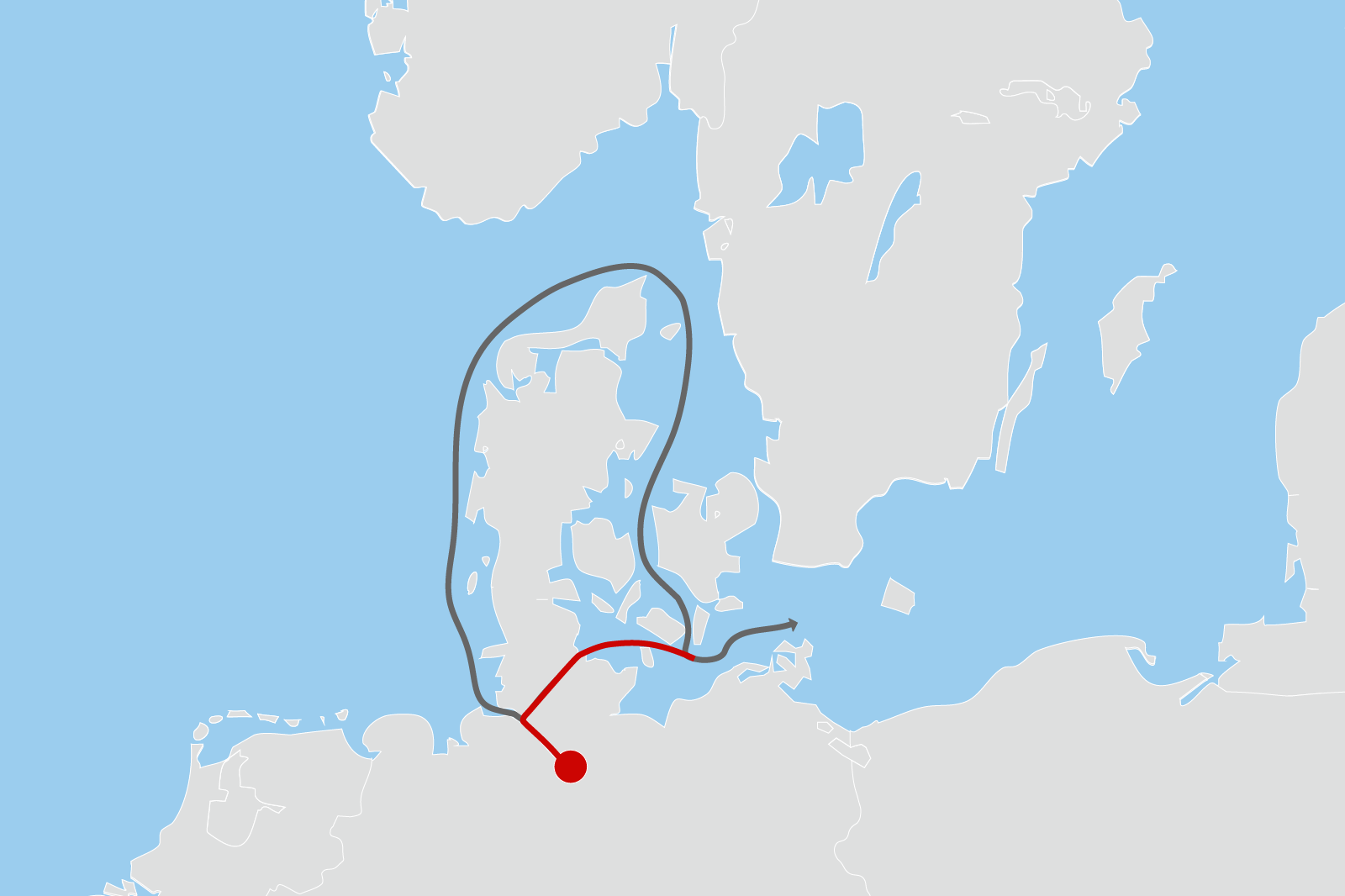
图源网络:平均而言,通过基尔运河运输可以节省260海里的路程,可以节省大约14-18小时。
Image Credit: shipping via the Kiel Canal saves about 260 nautical miles, which translates to approximately 14-18 hours.
此外,基尔运河的扩建工程进一步提升了其通航能力,使其能够满足更大吨位船舶的通行需求。这不仅缓解了公路和铁路运输的拥堵,还为汉堡港的集装箱运输提供了更高效的内河驳船航运能力。
- The Hub Role of the Port of Hamburg:
The Port of Hamburg is an important container hub in Europe, with goods such as machinery, electronic products, and chemical products being rapidly transported to Baltic Sea countries (e.g., Finland, Russia, Baltic States) via the Kiel Canal, covering the markets of Eastern and Northern Europe.
Infrastructure and Functional Zones
Container Terminals: The port has four modern container terminals (such as Burchardkai and Altenwerder), equipped with fully automated equipment, with an annual handling capacity of approximately 8.3 million TEUs.
Bulk and Liquid Terminals: The port's oil and natural gas terminals are linked with the LNG terminal in Brunsbüttel, transporting energy through the Kiel Canal to Baltic Sea countries.
Ro-Ro Terminals: The port's automobile import and export business relies on the canal route, with automakers transporting vehicles to the Scandinavian Peninsula. The port's automobile import and export volume is among the highest in Europe.
Cruise and Passenger Services: An important home port for cruise ships in Northern Europe, with over 2 million tourists received annually.
Logistics Network and Multimodal Transport
Rail: Over 50% of the port's logistics (the highest in Europe), with more than 200 freight trains operating daily to connect with the inland region.
Road and Inland Waterway: Synergies with the Elbe River and Kiel Canal form a "door-to-door" logistics system.
(3)汉堡港的枢纽作用:
汉堡港是欧洲重要的集装箱枢纽,其货物(如机械设备、电子产品、化工品)通过基尔运河快速转运至波罗的海国家(如芬兰、俄罗斯、波罗的海三国),覆盖东欧及北欧市场。
基础设施与功能分区
集装箱码头:4个现代化集装箱码头(如Burchardkai、Altenwerder),配备全自动化设备,年处理量约830万标准箱。
散货与液体码头:汉堡港的石油、天然气码头与布伦斯比特尔港的LNG终端联动,通过基尔运河向波罗的海国家输送能源。
滚装码头:汉堡港的汽车进出口业务依赖运河航线,车企通过运河将车辆运往斯堪的纳维亚半岛,汽车进出口量居欧洲前列。
邮轮与客运:欧洲北部重要邮轮母港,年接待游客超200万人次。
物流网络与多式联运
铁路占比超50%(欧洲最高),每日200多列货运列车连接内陆。
公路与内河航运(易北河、基尔运河)协同,形成“门到门”物流体系。
- Connections with Surrounding Countries
The Port of Hamburg, as a core transshipment hub in Europe, has economic links with surrounding countries as follows:
Northern and Baltic Sea Countries
Sweden/Denmark/Finland: Transport of timber, pulp, and machinery equipment via the Kiel Canal and short-sea shipping routes, with the import of automobiles and chemical products in return.
Poland/Baltic States: The Port of Gdańsk in Poland mainly transships electronic products and food to Eastern Europe via the Port of Hamburg.
Russia: Historically an important source of energy (oil, natural gas) and raw materials (timber, metals). After the Russia-Ukraine conflict, it shifted to Nordic energy alternatives.
Central and Eastern Europe
Czech Republic/Hungary/Austria: Industrial equipment and automotive parts are transported by rail to the Port of Hamburg for export.
"New Silk Road" Node: The China-Europe Railway Express (e.g., Chongqing-Hamburg) has promoted trade between China and Europe, with over 500 trains passing through the Port of Hamburg last year.
EU Policy Coordination
The EU's "Trans-European Transport Network (TEN-T)" has designated the Port of Hamburg as a core hub, promoting cross-border infrastructure with Poland and Denmark (e.g., the Fehmarn Belt Tunnel).
Green Energy Cooperation: Collaboration with Denmark on the transportation of offshore wind energy equipment and with Norway on the hydrogen energy supply chain.
(4)与周边国家的关联性
汉堡港作为欧洲核心转运枢纽,与周边国家的经济联系体现在以下方面:
北欧与波罗的海国家
瑞典/丹麦/芬兰:通过基尔运河和短途航线运输木材、纸浆、机械设备,反向输入汽车、化工品。
波兰/波罗的海三国:汉堡港是波兰格但斯克港的主要中转站,转运电子产品、食品至东欧。
俄罗斯:曾是能源(石油、天然气)和原材料(木材、金属)的重要来源,俄乌冲突后转向北欧能源替代。
中欧与东欧内陆
捷克/匈牙利/奥地利:通过铁路运输工业设备、汽车零部件至汉堡港出口。
“新丝绸之路”节点:中欧班列(如重庆-汉堡)推动中国与欧洲的贸易,去年经汉堡港的中欧班列超500列。
欧盟政策协同
欧盟“泛欧交通网络(TEN-T)”将汉堡港列为核心枢纽,推动与波兰、丹麦的跨境基建(如费马恩海底隧道)。
绿色能源合作:与丹麦合作海上风电设备运输,与挪威联动氢能供应链。
Natural Constraints on the Port
Elbe River Channel Limitations
Insufficient Water Depth: The main channel is currently dredged to 13.5 meters, but large container ships (e.g., 20,000 TEU class) require a water depth of over 14.5 meters, leading to some vessels having to wait for high tide or reduce their load.
Siltation: The Elbe River has an annual siltation volume of about 3 million cubic meters, with dredging costs exceeding 100 million euros per year, and significant environmental controversy (destruction of wetland ecosystems).
Tidal and Weather Impacts
Significant Tidal Range: The North Sea has a tidal range of 3-4 meters, requiring ships to coordinate with tidal cycles for entry and exit, affecting operational efficiency.
Winter Ice Conditions: Under extreme weather conditions, the Elbe River occasionally has floating ice, requiring icebreaker escort (about 10 days per year).
Urban Geographic Constraints
The port is intertwined with the city of Hamburg, with limited expansion space and high land costs, restricting the construction of new terminals.
(5)自然条件对港口的约束
易北河航道限制
水深不足:主航道目前疏浚至13.5米,但大型集装箱船(如2万TEU级)需14.5米以上水深,导致部分船舶需候潮或减载。
泥沙淤积:易北河年均淤积量约300万立方米,疏浚成本高昂(年耗资超1亿欧元),且环保争议大(破坏湿地生态)。
潮汐与天气影响
潮差显著:北海潮差达3-4米,船舶进出需配合潮汐周期,影响作业效率。
冬季冰情:极端天气下易北河偶有浮冰,需破冰船护航(年均约10天)。
城市地理限制
港口与汉堡市区交织,扩建空间有限,土地成本高昂,制约新码头建设。
Ⅴ Recent Events and Underlying Cause Analysis
五、近期事件一览及背后原因分析
Strike Incident
In March 2025, a large-scale strike occurred in northern Germany, leading to the closure of the Kiel Canal and severely impacting the operations of certain areas of the Port of Hamburg. The strike not only disrupted the normal navigation of the Kiel Canal but also caused delays in cargo transportation at the Port of Hamburg, highlighting the indispensability of the Kiel Canal to the port's operations.
罢工事件:
2025年3月,德国北部发生了一场大规模罢工,导致基尔运河关闭,对汉堡港的部分地区运营产生了严重影响。此次罢工不仅影响了基尔运河的正常通航,还导致汉堡港的货物运输出现延误,凸显了基尔运河对汉堡港运营的不可或缺性。
Ship Collision Incidents
(1) February 6, 2025
Two container ships collided in front of the Holtenau lock in the Kiel Canal. The accident was likely caused by dense fog reducing visibility. The ships collided during close-quarters maneuvering while passing through the lock. Fortunately, there were no casualties or pollution.
(2) February 1, 2025
A container ship collided with the New North Lock of the Kiel Canal due to engine failure, causing damage to the lock.
(3) January 20, 2025
A harbor ferry collided with a push-tow barge convoy in the North Elbe River of the Port of Hamburg, resulting in 11 injuries, including one serious case. The accident occurred when the ferry turned towards the pier and collided with the barge, causing the barge to detach and collide with the ferry.
(4) January 2, 2025
A cargo ship collided with the lock of the Kiel Canal, a key waterway leading to the Port of Hamburg, due to engine failure. The accident caused a large pit measuring 2 meters deep and 8-10 meters wide in the lock, rendering it temporarily unusable. Although the offending ship was moored inside the lock for safety inspection, navigation had to be rerouted.
撞船事故
(1)2025年2月6日
两艘集装箱船在基尔运河霍尔特瑙船闸前方相撞。事故可能是由于浓雾导致能见度低,两船在通过船闸时近距离交会时发生碰撞。所幸未造成人员伤亡或污染。
(2)2025年2月1日
集装箱船因发动机故障撞上基尔运河新北船闸,导致船闸受损。
(2)2025年1月20日
一艘港口渡轮与一艘由推船和驳船组成的推驳船队在汉堡港北易北河相撞,导致11人受伤,其中1人重伤。事故发生在渡轮转向码头时,渡轮撞上了驳船,导致驳船脱离并与渡轮发生碰撞。
(3)2025年1月2日
一艘货轮因发动机故障失控,撞上了通往汉堡港的关键航道——基尔运河的船闸。事故导致船闸出现一个深2米、宽8至10米的大坑,船闸暂时无法使用。尽管肇事船已停泊在闸室内进行安全检查,但船舶航行不得不改道。
Cause Analysis
- Natural Conditions
(1) Visibility Interference (e.g., February 6, 2025 Fog Incident)
The area where the North Sea meets the Baltic Sea is prone to fog in winter, often reducing visibility to below 500 meters. Ship radars struggle to accurately avoid collisions in such narrow waterways, increasing the risk of close-quarters collisions.
(2) Hydrological Complexity
The tidal range and turbulent sections of the canal (e.g., the Brunsbüttel lock entrance) increase navigation difficulty, especially for large vessels (e.g., the container ship with engine failure on February 1). The January 20 accident involving a harbor ferry and a barge convoy highlighted the structural risks associated with traditional push-tow configurations, which are susceptible to breaking apart under water flow impacts.
2. Human Operational Errors
(1) Fatigue and Inexperience
The Kiel Canal sees over 80 ships passing through daily, leading to high-intensity operations and crew fatigue. Some new crew members fail to strictly adhere to lock operating procedures, such as speed limits of 10 knots and single-direction traffic rules.
(2) Delayed Emergency Response
In the January 20 ferry collision, the failure to promptly initiate emergency mooring procedures after a steering error exposed coordination and command loopholes.
3 Vessel Mechanical Failures
(1) Aging Power Systems
The engine failures in the February 1 and January 2 incidents both involved container ships over 15 years old. Insufficient maintenance led to sudden failures of critical components such as fuel pumps and steering gear.
(2) Structural Risks in Push-Tow Barge Convoys
The rigid connection between push boats and barges in traditional configurations, as seen in the January 20 accident, is prone to breaking under water flow impacts, posing significant safety hazards in canal navigation.
4. Traffic Management Pressures
(1) Overcapacity
The Kiel Canal's designed capacity is 35,000 ships per year, but in 2024, the actual traffic volume reached 41,000 ships. This congestion increases the risk of ship-to-ship collisions during close-quarters maneuvers.
(2) Navigation Rule Conflicts
Some vessels from Northern European countries still follow "open-sea collision avoidance rules," which conflict with the canal's mandatory "lock priority" system (e.g., the January 2 incident where a cargo ship's gate-rushing behavior led to a collision).
5. Infrastructure Bottlenecks
(1) Aging Locks
The Holtenau Lock (commissioned in 1907) and the New North Lock (expanded in 1965) have outdated equipment. The lock gate opening and closing delay rate exceeds 15%, prolonging ship dwell times.
(2) Narrow Channel Width
The main channel's width of only 32.5 meters forces large vessels (e.g., 24-row container ships) to navigate "close to the wall," leaving minimal room for error.
事故原因分析
- 自然条件限制
能见度干扰(如2025年2月6日浓雾事故):
北海与波罗的海交汇区冬季多雾,能见度常低于500米,船舶雷达在狭窄航道中难以精准避让,易引发近距离碰撞。
水文复杂性:
运河潮汐差、水流湍急段(如布伦斯比特尔闸口)加剧操控难度,尤其对大型船舶(如2月1日发动机故障的集装箱船)构成挑战。
- 人为操作失误
疲劳驾驶与经验不足:
运河日均通行船舶超80艘,高强度作业导致船员疲劳;部分新船员对船闸操作规范(如限速10节、单向通行规则)执行不严。
应急响应滞后:
2025年1月20日渡轮碰撞事故中,转向失误后未能及时启动紧急停泊程序,暴露协同指挥漏洞。
- 船舶机械故障
动力系统老化:
2月1日和1月2日两起发动机失控事件均涉及船龄超15年的集装箱船,维护不足导致关键部件(如燃油泵、转向舵机)突发失效。
推驳船队结构风险:
1月20日事故中推船与驳船的刚性连接易受水流冲击断裂,此类传统船型在运河中安全隐患突出。
- 交通管理压力
超负荷运转:
基尔运河设计通行能力为年3.5万艘,2024年实际通行量已达4.1万艘,拥堵加剧船舶交汇风险。
导航规则冲突:
部分北欧国家船舶沿用“开放式海域避让规则”,与运河强制“船闸优先权”制度冲突(如1月2日货轮抢闸引发碰撞)。
- 基础设施瓶颈
船闸老化:
霍尔特瑙船闸(1907年启用)和新北船闸(1965年扩建)设备陈旧,闸门启闭延迟率超15%,延长船舶滞留时间。
航道宽度限制:
仅32.5米宽的主航道迫使大型船舶(如24排集装箱船)以“贴壁航行”通过,容错空间极小。
Conclusion
The Kiel Canal, as a vital waterway connecting the North Sea and the Baltic Sea, holds undeniable shipping value. However, this collision incident once again highlights the importance of shipping safety management. Although the accident did not cause significant casualties, the underlying issues of human oversight, streamlined operational procedures, and the pressure on the captain are worthy of deep reflection within the shipping industry.
The close connection between the Kiel Canal and the Port of Hamburg is not only geographical but also deeply rooted in their impact on European shipping economy and logistics efficiency. This accident has had a short-term impact on the canal's navigation capacity and the port's operational efficiency, prompting further contemplation on shipping safety management and infrastructure development.
In the future, as the shipping industry continues to develop and technology progresses, the Kiel Canal and the Port of Hamburg need to continuously optimize in terms of intelligence, green development, and safety management. By strengthening crew training, improving operational procedures, enhancing the intelligence level of waterway facilities, and strengthening international cooperation, the Kiel Canal and the Port of Hamburg are expected to ensure shipping safety while further enhancing their important positions in global shipping.
结语
基尔运河作为连接北海与波罗的海的重要航道,其航运价值不言而喻。然而,此次撞闸事件再次凸显了航运安全管理的重要性。事故虽未造成重大人员伤亡,但其背后反映出的人为疏漏、操作流程简化以及船长压力等问题,值得航运界深刻反思。
基尔运河与汉堡港的紧密联系,不仅体现在地理位置上,更在于其对欧洲航运经济和物流效率的深远影响。此次事故对基尔运河的通航能力以及汉堡港的运营效率均产生了短期冲击,也引发了对航运安全管理和基础设施建设的进一步思考。
未来,随着航运业的不断发展和技术的进步,基尔运河与汉堡港需要在智能化、绿色化和安全管理方面持续优化。通过加强船员培训、完善操作流程、提升航道设施的智能化水平以及加强国际合作,基尔运河与汉堡港有望在保障航运安全的同时,进一步提升其在全球航运中的重要地位。
 RELATED NEWS
 Hotline
 Email
Email

 沪公网安备 31011502016705号
Disclaimer:
This communication has been prepared for general information only. To the maximum extent permitted by law, E-PORTS and its affiliated companies, its and their employees, directors, agents, contractors (of any tier) and partners shall not be liable for any loss, claim, charge, damage, liability or damages howsoever arising in connection with the information even if advised of the possibility of damages. The use of the information shall be at your sole risk. Information contained herein comes with no representation or warranty (express or implied) and specifically is not represented or warranted to be correct, complete, accurate or up to date. The information is provided on an “as is” and “as available” basis and is not intended to be relied upon in any way. You shall be solely responsible for the selection, use, efficiency and suitability of the information.


 Chat with us