
Bulk Carrier Explosion in Goa Waters! Chinese Crew Member Dies! 果阿海域散货船爆炸!中国籍船员遇难!
Bulk Carrier Explosion in Goa Waters! Chinese Crew Member Dies!
果阿海域散货船爆炸!中国籍船员遇难!
In the early hours of March 21, 2025, the Indian Navy successfully executed a high - difficulty medical evacuation operation 230 nautical miles (approximately 426 kilometers) west of Goa in the Arabian Sea. The rescue targets were four crew members severely burned due to a bulk carrier explosion, among whom two Chinese nationals and one Indonesian national were rescued, while another Chinese crew member unfortunately died from severe injuries.
2025年3月21日凌晨,印度海军在阿拉伯海果阿以西230海里处(约426公里)成功执行了一次高难度医疗撤离行动。此次救援对象为因散货船爆炸而严重烧伤的四名船员,其中两名中国籍、一名印尼籍船员获救,另一名中国籍船员因伤势过重已不幸遇难。
After receiving the distress signal in the late night of March 20, the Mumbai Maritime Rescue Coordination Center (MRCC) of the Indian Coast Guard immediately activated a multi - departmental coordinated response mechanism. As the main maritime force in the Indian Ocean region, the Indian Navy swiftly mobilized an aircraft carrier and a fleet replenishment ship, which were on strategic patrol duty, to form a task force. The task force increased its speed to 28 knots and rushed to the incident area at full speed. The cause of the accident is still under investigation. It is reported that under the direction of the coast guard, the damaged vessel is now heading to Mormugao Port.
印度海岸警卫队孟买海上救援协调中心(MRCC)于3月20日深夜接获求救信号后,立即启动多部门协同响应机制。作为印度洋地区主要海上力量,印度海军迅速调动正在执行战略巡航任务的航母和舰队补给舰组成特遣编队,航速提升至28节全速赶赴事发海域。目前,事故原因还在调查当中。据报道,在海岸警卫队的指示下,受损船只目前正驶往莫尔穆冈港(Mormugao Port)。
Bulk carriers face complex natural environments and potential safety hazards while sailing at sea. The specific cause of the accident is still unknown. In this issue, through a detailed analysis of the geographical location, climatic conditions, port structure, shipping route distribution, and historical accidents of the incident area, we can gain some insights into the surrounding environment of the accident and prevent similar tragedies from happening again.
散货船在海上航行时,面临着复杂的自然环境和潜在的安全隐患。事故发生的具体原因我们还不得而知,本期我们通过对事发海域的地理位置、气候条件、港口结构、航线分布以及历史事故的详细分析,我们可对事故发生的周遭环境探之一二,避免类似悲剧的再次发生。
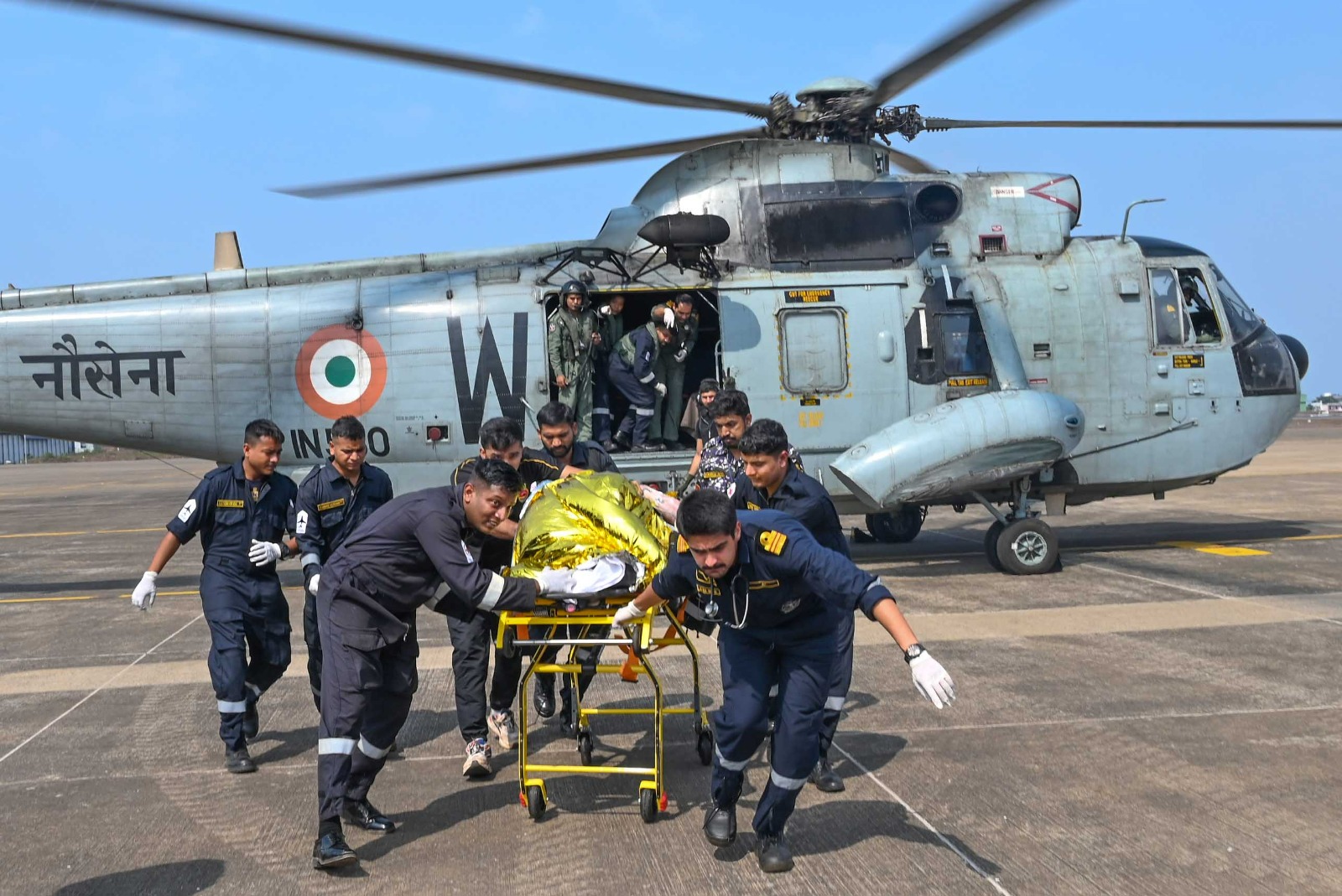
Image Credit: Internet Indian Coast Guard personnel during rescue of vessel crew member.
图源网络: 印度海岸警卫队人员在救助船员
Ⅰ Geographical Location and Climatic Conditions
一、地理位置与气候条件
Geographical Location: The incident waters are located in the Arabian Sea off the Konkan region on the west coast of India. Goa, the smallest state in India, is bordered by the Arabian Sea to the west and the Western Ghats to the east. The region has a coastline of 101 kilometers, consisting of sandy beaches, rocky capes, mangrove estuaries, and alluvial islands. There are more than 40 estuaries and over 90 river islands distributed near the shore.
地理位置:事发水域位于印度西海岸康坎地区(Konkan)的阿拉伯海海域。果阿邦作为印度最小邦,西临阿拉伯海,东接西高止山脉(Western Ghats)。该区域海岸线长达101公里,由沙质海滩、岩石岬角、红树林河口及冲积岛屿构成,近岸分布40余个河口和90多个河流岛屿。
Climatic Conditions: The Konkan region is the core area affected by the southwest monsoon in India. From June to September each year is the heavy rainfall season, with an annual rainfall of up to 2,000 - 5,000 millimeters along the coast, and even higher in some local areas (such as Goa). During the monsoon season, deep - layer cloud systems and low - pressure systems generated in the Arabian Sea often lead to short - term extreme rainfall. For example, in July 2024, the Konkan - Goa area received a daily rainfall of 230 millimeters, causing floods and landslides. From March to May, during the pre - monsoon transition period, there are often convective thunderstorms with wind speeds reaching 35 - 55 kilometers per hour, resulting in severe sea conditions.
气候条件:康坎地区是印度西南季风的核心影响区,每年6月至9月为强降雨季,沿海年降雨量可达2000-5000毫米,局部地区(如果阿)甚至更高。季风期间,阿拉伯海生成的深层云系统和低气压常导致短时极端降雨,例如2024年7月康坎-果阿地区单日降雨量达230毫米,引发洪水与山体滑坡。3-5月季风前过渡期则多对流性雷暴,风速可达35-55公里/小时,海况恶劣。
At the end of March, just before the monsoon season, the average wind speed in the area can reach 15 - 20 knots, with wave heights of 2 - 3 meters, posing a significant challenge for helicopter winch operations. The climate characteristics of Goa show that at this time, the diurnal temperature difference is relatively large (29°C during the day / 20°C at night), with a humidity of about 75%, which may accelerate the risk of infection for the injured. The area is about 50 nautical miles away from the main international shipping routes. Merchant ships need to cross the busy shipping lanes along the west coast of India to reach the Persian Gulf and Africa. The high density of ships means limited space for emergency evasion.
3月下旬正值季风季前夕,该海域平均风速可达15-20节,浪高2-3米,对直升机绞车作业构成显著挑战。果阿气候特征显示,此时昼夜温差较大(日间29°C/夜间20°C),湿度约75%,可能加速伤员感染风险。该海域距国际主航线约50海里,商船需穿越印度西海岸通往波斯湾与非洲的繁忙航道,船舶密度高,紧急避让空间有限。
Ⅱ The Dual - Core Structure of the Goa Port Cluster
二、果阿港群的双核结构
Mormugao Port (73.81E, 15.38N):
As the nearest deep - water port to the incident site, Mormugao Port is the largest port for iron ore exports in India. Located in Goa, it is larger than Panaji Port. The port has a 15 - meter - deep channel, capable of accommodating 200,000 - ton bulk carriers. It is equipped with an automated loading and unloading system and a railway directly connected to the inland mining area. Its strategic location makes it a key node in the "Golden Quadrilateral" shipping network on the west coast of India (Mumbai - Cochin - Mundra - Mormugao).
The port has 11 main berths, including specialized berths for ore and oil. Loading and unloading equipment includes various shore cranes, steam cranes, and tugs. The largest shore crane has a lifting capacity of 30 tons, and the port's annual cargo throughput is approximately 20 million tons. In addition to iron ore, Mormugao's main exports include soybean meal and dried fruit. The main imports are coal, grain, automobiles, cement, fertilizers, and petroleum products.
- 莫尔穆冈港(MormugaoPort,81E,15.38N) :
- 作为距离事发地最近的深水港,莫尔穆冈港是印度铁矿石出口第一大港,位于果阿邦,比帕纳吉港大一些,该港拥有15米深航道,可停泊20万吨级散货船,配备自动化装卸系统和铁路直连内陆矿区。其战略位置使其成为印度西海岸"金四边形"航运网络(孟买-科钦-蒙德拉-莫尔穆戈)的关键节点。
- 港区主要码头泊位有11个,其中包括矿石和石油等专用泊位。装卸设备有各种岸吊、蒸汽吊及拖船等,其中岸吊最大起重能力为30吨,年货物吞吐能力约2,000万吨。莫尔穆冈主要出口货物除矿石外,还有豆饼及干果等,进口货物主要有煤、粮食、汽车、水泥、化肥及石油产品等。
New Mangalore Port: Located north of the mouth of the Gurpur River in the state of Karnataka on the southwest Indian peninsula, northwest of Mangalore city and facing the Arabian Sea, it is the ninth largest port in India. It is 203 nautical miles south by sea from Cochin Port, 512 nautical miles from Colombo Port, 173 nautical miles north from Mormugao Port, 395 nautical miles to Mumbai Port, and 854 nautical miles to Karachi Port.
新芒格洛尔港( New Mangalore Port):位于该国印度半岛西南卡纳塔克邦古尔普尔河口之北,芒格洛尔城西北,临阿拉伯海,为印度第九大港口。海路南距科钦港203海里,距科伦坡港512海里,北距莫尔穆冈港173海里,至孟买港395海里,卡拉奇港854海里。
The port is excavated from the land, surrounded by land on the north, east, and south sides. Ships enter through the western entrance. The channel is 13.5 meters deep and 245 meters wide, protected by two short breakwaters. On the northeast side of the inner harbor is the bulk cargo wharf, 594 meters long with three bulk berths. The front - end water depth ranges from 9.44 meters to 10.66 meters. The southern end is 250 meters long with a water depth of 10.66 meters, while the northern end is 115 meters long with a water depth of 6.71 meters for general cargo. The wharf is connected to the railway. On the southeast side of the inner harbor is the iron ore export wharf, 290 meters long with a front - end water depth of 13 meters, capable of accommodating 60,000 - ton ore carriers. The loading machine on the wharf has an efficiency of 3,000 - 4,000 tons per hour. On the southwest side, which is the right side of the entrance, there is an oil wharf with a front - end water depth of 10.3 meters, capable of accommodating 30,000 - ton oil tankers with a length of 183 meters. Although the port does not have many berths, it has a large capacity. It mainly exports manganese, chromium, iron ore, and imports fertilizers, petroleum, and general cargo. In summer, the southwest monsoon often blows with an average wind force of 5 - 6, and it is also affected by tropical storms. The tide is semi - diurnal, with an average spring tide high tide of 1.4 meters and low tide of 0.4 meters, and an average neap tide high tide of 1.3 meters and low tide of 0.9 meters.
该港由陆岸人工挖掘而成,北、东、南三面被陆岸包围,船舶由西路口,航道水深13.5米,宽245米,由两条短防波堤拱卫。港内水域东北岸为散货码头,长594米,是3个散货泊位,前沿水深9.44米-10.66米;南端250米,前沿水深10.66米;北端长115米,水深6.71米,用于杂货,该码头有铁路通达。港内水域东南岸为铁矿石出口码头,长290米,前沿水深13米,可泊6万吨级矿石船,码头上装矿机效率每小时3000-4000吨;西南岸即入口右岸是一个石油码头,前沿水深10.3米,可泊长183米长3万吨级油轮。该港水港泊位虽不多但能量大,输出锰、铬、铁矿石为主,进口化肥、石油、杂货。夏季常吹西南风,风力平均达5-6级,还受热带风暴影响。潮汐属半月型,平均大潮高潮1.4米,低潮0.4米,平均小潮高潮1.3米,低潮0.9米。
The port exports minerals, pepper, coffee, sandalwood, cashew nuts, tea, etc. About 2 nautical miles to the south of the new port is the original port with a small scale, mainly used for coastal trade and fisheries. About 10 kilometers to the south of Mangalore city's port, it is about 10 kilometers away from the new port and about 6 kilometers away from the old port.
输出矿产、胡椒、咖啡、檀香木、腰果、茶叶等。新港至南约2海里原有港口规模小,主要用于沿海贸易与渔业。芒格洛尔市港口至南,与新港相距约10公里,与老港相距约6公里。
Ⅲ Shipping Route Distribution in the Region
三、区域航线分布
International Trunk Lines: The main shipping routes passing through the area include the Persian Gulf - Malacca energy corridor (eastward crude oil transport), the Asia - Europe container shipping route (via the Suez Canal), and the Africa - South Asia bulk cargo trade line.
Regional Feeder Lines: Mormugao Port forms an iron ore triangle transportation network with nearby Mumbai Port (365 nautical miles away) and New Mangalore Port (230 nautical miles away).
Konkan Marine Expressway: India's first marine expressway, featuring seven sea - crossing bridges and a designed speed of 18 knots, reduces the sailing time from Mumbai to Goa to just six hours.
- 国际干线:通过该水域的主航线包括波斯湾-马六甲能源通道(原油东输)、亚欧集装箱航线(经苏伊士运河)、非洲-南亚散货贸易线。
- 区域支线:莫尔穆戈港与邻近的孟买港(距离365海里)、新芒格洛尔港(距离230海里)形成铁矿石三角运输网。
- 新建康坎海上高速路(Konkan Marine Expressway):印度首条海上高速路,含7座跨海大桥,设计航速18节,将孟买至果阿航行时间压缩至6小时。
Ⅳ Historical Accident Review
历史事故回溯
As a core area of the Arabian Sea shipping network, the waters 230 nautical miles west of Goa (between 14° - 16°N and 70° - 73°E) are not only a key node in the energy corridor but also a high - incidence area for shipping accidents. Based on historical accident data and geographical features, the types and causes of accidents in this area can be summarized as follows:
作为阿拉伯海航运网络的核心区域,果阿以西230海里海域(北纬14°-16°、东经70°-73°)既是能源通道的关键节点,也是船舶事故高发区。结合历史事故资料与地理特征,该海域的事故类型与成因可归纳如下:
Extreme Weather - Induced Ship Disasters
Tropical Cyclones and Monsoon Disasters
The area is located on the western edge of the Arabian Sea cyclone - generating belt, with a high - risk period from May to November each year. In 2021, Cyclone Tauktae generated a maximum sustained wind speed of 220 kilometers per hour in this region, causing five barges to sink in the Mumbai anchorage and trapping 714 people.
Hydrological Challenges During the Monsoon Season
During the southwest monsoon season from June to September, the average wave height in the area is 4 - 6 meters, combined with a westward surface current (with a speed of 1.5 - 2.5 knots), which can easily cause ships to lose lateral stability. In June 2013, a container ship broke and sank about 650 nautical miles west of this area, with 4,382 containers scattered. Among them, six containers of hazardous chemicals were pushed to the coast of Kerala, India, by the ocean current, exposing the fatal flaw of insufficient structural strength of ships during the monsoon season.
(1)极端天气引发的船舶灾难
热带气旋与季风灾害
该海域位于阿拉伯海气旋生成带西缘,每年5-11月为高危期。2021年气旋"陶克泰"(Tauktae)曾在此区域生成最大持续风速220公里/小时的超强气旋,导致孟买锚地5艘驳船沉没、714人被困。
季风期水文挑战
6-9月西南季风期间,海域平均浪高4-6米,叠加西向表层流(流速1.5-2.5节),易引发船舶横向失稳。2013年6月,一艘集装箱船在此海域以西约650海里处断裂沉没,4382个集装箱散落,其中6个危险化学品罐被洋流推送至印度喀拉拉邦海岸,暴露了季风期船舶结构强度不足的致命缺陷。
Shipping - Dense Area Collision Accidents
Cross - Route Risk
The area has a daily ship traffic volume of over 200 vessels, including more than 50 oil tankers on the Persian Gulf - Malacca energy corridor, the Asia - Europe container trunk line, and the Africa - South Asia bulk cargo route. In April 2021, a 354 - meter - long container ship collided with an Indian fishing boat here, causing the fishing boat to sink and three deaths. The accident investigation showed that the radar of the merchant ship failed to identify the small wooden fishing boat, and the fishing boat was not equipped with an AIS system, highlighting the regulatory blind spot in mixed - route navigation.
航运密集区的碰撞事故
国际航线交叉风险
该海域日均船舶流量超200艘次,汇集波斯湾-马六甲能源通道(日均50+油轮)、亚欧集装箱干线、非洲-南亚散货航线。2021年4月,354米长的集装箱船在此与印度渔船相撞,导致渔船沉没、3人死亡。事故调查显示,商船雷达未能识别小型木质渔船,且渔船未配备AIS系统,凸显航线混行监管盲区。
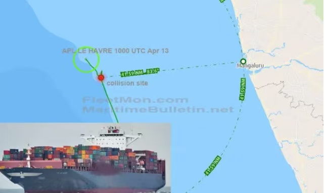
Image Credit:Internet
图源网络
Geographical Environment Threats
River Estuary Sediment Dynamics Threat
The Zuari and Mandovi rivers along the Goa coast transport 12 million tons of sediment to the sea every year, forming mobile sandbars. According to a report from the National Institute of Oceanography (NIO) in India, the sediment in the Zuari and Mandovi rivers contains significantly higher levels of manganese, iron, cobalt, and other elements due to iron ore transportation, causing channel siltation. The fine particles (< 0.1 millimeter) generated during the loading and unloading of ore are highly suspended. Combined with the strong runoff during the monsoon season, the actual sediment transport volume may reach 20 - 30 times the theoretical value. As the largest iron ore export port in India, Mormugao Port's 15 - meter - deep channel needs to maintain an effective width of 18 meters. The dredging project in 2023 might be in response to abnormal sedimentation events during the monsoon season, similar to the channel crisis in the Jamuna River sandbar area caused by a sediment transport volume of 600 million tons per year.
(3)、地理环境的威胁
河口沉积物动态威胁
果阿海岸的祖阿里河(Zuari)、曼多维河(Mandovi)每年向海域输送1200万吨泥沙,形成移动沙洲。根据印度国家海洋研究所(NIO)报告,祖阿里河和曼多维河因铁矿石运输导致航道淤积,沉积物中锰、铁、钴等元素含量显著升高。矿石在装卸过程中产生的细微颗粒(<0.1毫米)极易悬浮,结合季风期强径流,可能使实际输沙量达到理论值的20-30倍。莫尔穆戈港作为印度最大铁矿石出口港,其15米深航道需维持18米有效宽度。2023年的疏浚工程可能是应对季风期异常沉积事件,类似贾穆纳河沙洲区因6亿吨/年输沙量引发的航道危机。
This incident also reminds us that the waters off Goa and its surrounding areas, as an important global shipping corridor, face many challenges. The interplay of extreme weather, dense shipping, and complex geographical environment makes this area a high - incidence zone for ship accidents. In the future, strengthening international cooperation and information sharing, improving the maritime safety supervision system, enhancing the infrastructure construction of ports and channels, and further optimizing emergency rescue capabilities will be the keys to ensuring maritime safety and humanitarian rescue in this region.
这一事件也提醒我们,果阿外海及其周边海域作为全球重要的航运通道,面临着诸多挑战。极端天气、航运密集、地理环境复杂等因素交织,使得这片海域成为船舶事故的高发区。未来,加强国际间的合作与信息共享,完善海上安全监管体系,提升港口与航道的基础设施建设,以及进一步优化应急救援能力,将是保障该地区海洋安全与人道主义救援的关键所在。
With the development of economic globalization, the shipping industry is booming, and maritime transport is becoming increasingly busy. The number of ships is constantly increasing, and the number of crew members has also grown significantly. This has led to an increase in the number of crew rescue incidents. The importance of professional rescue platforms is becoming more and more prominent. E - PORTS has extensive experience in crew rescue and has successfully handled many emergency rescue cases. In 2024, off the coast of Chile in the eastern Pacific, a crew member on a cargo ship suddenly fell seriously ill. E - PORTS used digital means to quickly coordinate the rescue team, arrange for the ship to urgently dock at the nearest port, and have the shore - based medical team ready. After timely rescue, the crew member finally got out of danger and returned to China for further treatment. If you need crew rescue, you can contact us:
WhatsApp/WeChat: 13816101982
Email: contact@e - ports.com
随着全球经济一体化,航运业蓬勃发展,海上运输日益繁忙,船只数量不断增加,相应的船员数量也大幅增长,这使得船员救助事件在数量上有增多趋势。专业的救助平台的重要性日益凸显,E-PORTS拥有丰富的船员救助经验,曾成功处理多起紧急救助案件,2024年在东太平洋智利沿岸,一艘货船上1名船员突发急病,E-PORTS通过数字手段,迅速协调救援团队,就近安排该船紧急停泊港口,岸上医疗团队也已准备就位,船员上岸后并第一时间送入重症监护室进行科学治疗。经过及时的救助,这名船员终于脱离了危险,顺利返回中国,接受后续治疗。如果需要船员救助,可联系我们:
WhatsApp/WeChat:13816101982
Email:contact@e - ports.com
 RELATED NEWS
 Hotline
 Email
Email

 沪公网安备 31011502016705号
Disclaimer:
This communication has been prepared for general information only. To the maximum extent permitted by law, E-PORTS and its affiliated companies, its and their employees, directors, agents, contractors (of any tier) and partners shall not be liable for any loss, claim, charge, damage, liability or damages howsoever arising in connection with the information even if advised of the possibility of damages. The use of the information shall be at your sole risk. Information contained herein comes with no representation or warranty (express or implied) and specifically is not represented or warranted to be correct, complete, accurate or up to date. The information is provided on an “as is” and “as available” basis and is not intended to be relied upon in any way. You shall be solely responsible for the selection, use, efficiency and suitability of the information.


 Chat with us